Today’s surveying world is changing faster than ever, and getting accurate results is more important than ever. Handheld RTK GNSS devices are a game-changer for professionals who need precision on the go. They really help bridge the gap between old-school methods and cutting-edge tech, making fieldwork a lot easier and more reliable.
What’s really great about these handheld units is how accessible they are. Surveyors can grab real-time data on the spot, which means work gets done faster, and there’s less room for mistakes. But honestly, with so many options out there, it can get pretty overwhelming. Not every device offers the same level of support and accuracy, so it’s super important to know what each one can really do before making a choice.
And let’s not forget—reliability is a big deal. Sure, Handheld Rtk Gnss systems can seriously speed things up, but they’re not flawless. Sometimes, you’ll run into issues like signal drops or battery troubles. By keeping these things in mind, companies can approach their surveying with realistic expectations and be ready to adapt when things don’t go exactly as planned. It’s all about staying flexible and making the most of the tech at hand.

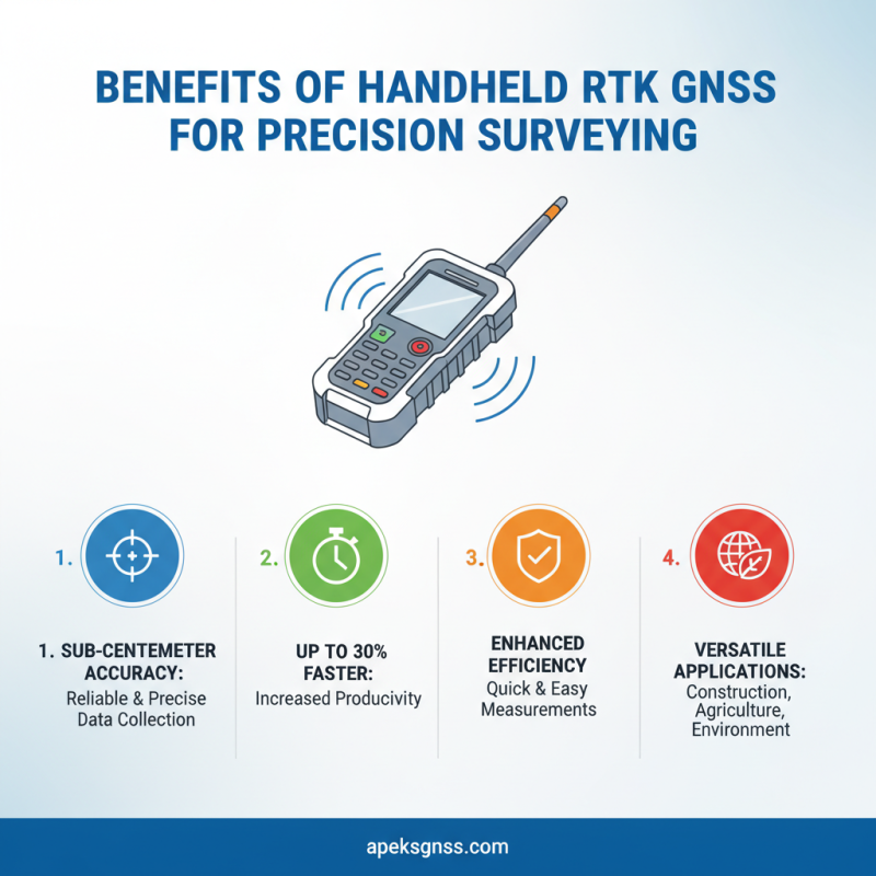
Benefits of Handheld RTK GNSS for Precision Surveying
Handheld RTK GNSS technology has transformed the landscape of precision surveying. With sub-centimeter accuracy, these devices empower surveyors to collect reliable data quickly and efficiently. According to industry reports, using Gnss Rtk Handheld devices can enhance productivity by up to 30% compared to traditional methods. This efficiency is critical in various applications, including construction, agriculture, and environmental monitoring.
The portability of Gnss Rtk handheld units allows surveyors to operate in remote or rugged terrains. Operators can integrate the collected data seamlessly into their workflows, minimizing the need for cumbersome equipment. However, users often face challenges with signal loss in densely built environments. Despite this, advancements in technology continue to address these issues, promoting greater reliability.
The ability to achieve high precision in surveying not only improves project outcomes but also adds value to decision-making processes. Data accuracy directly influences planning and execution, underscoring the significance of utilizing GNSS RTK handheld devices. Surveyors are urged to weigh the pros and cons of their options, ensuring they choose a solution that meets their specific project needs while considering potential limitations.
Understanding RTK GNSS Technology Fundamentals
RTK GNSS technology has transformed surveying by enhancing accuracy and efficiency. This technology works by using real-time kinematic positioning, which allows surveyors to pinpoint locations with centimeter-level precision. According to a recent report from the U.S. Department of Transportation, the adoption of GNSS technology in surveying has increased productivity by up to 30%. This is crucial for large-scale projects where precision is non-negotiable.
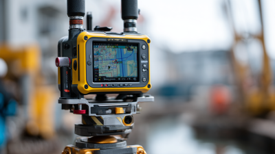
Handheld Rtk Gnss Devices are compact and user-friendly. They can be deployed in various terrains, making them invaluable in remote areas. Surveys conducted with these devices have shown reduced errors. A study by the National Institute of Standards and Technology (NIST) highlighted that traditional methods have inaccuracies ranging from 5 to 10 centimeters. In contrast, handheld RTK GNSS devices can achieve an accuracy of within 1 to 2 centimeters. However, the effectiveness of these devices may depend on local satellite coverage and environmental conditions.
Surveying professionals must understand both the strengths and limitations of RTK GNSS. While these devices provide impressive accuracy, factors like multipath effects and signal loss in dense urban areas can introduce challenges. Real-world results often require calibration and adjustments. As the industry evolves, continuous training on RTK GNSS technology becomes essential for surveyors to maximize its benefits and ensure data reliability.
Applications of Handheld RTK GNSS in Various Industries
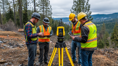
Handheld RTK GNSS technology is revolutionizing surveying across various industries. In construction, precise site measurements are crucial. Handheld devices provide real-time data, enhancing accuracy. Surveyors can easily mark points and assess land features with minimal error. This immediacy streamlines projects and reduces costly mistakes.
In agriculture, farmers use these devices for precision farming. They can map fields accurately, optimizing resource use. This leads to higher crop yields and sustainable practices. Real-time positioning helps in planning plant density and irrigation needs, benefiting both the environment and profit margins.
Tips for effective use of Handheld RTK GNSS: Ensure regular calibration for the most accurate readings. Familiarize yourself with the device’s features for maximum efficiency. In challenging terrains, always verify data through additional checks. Though handheld technology offers great advantages, users should remain aware of potential limitations, such as signal loss in dense forests or urban areas. Understanding these challenges can improve overall reliability in data collection.
Comparison: Handheld RTK GNSS vs. Traditional Surveying Methods
Handheld RTK GNSS offers a modern approach to surveying that contrasts sharply with traditional methods. Traditional surveying requires bulky equipment and extensive manpower. This often leads to lengthy setup times and inaccurate results in challenging environments. Many surveyors grapple with these limitations, impacting their project timelines and budgets.
In contrast, handheld RTK GNSS systems provide ease of use and portability. Surveyors can operate these devices efficiently in diverse terrains. They achieve high accuracy without the cumbersome setups of older methods. Many professionals have reported significant time savings, allowing for quicker decisions and more reliable data collection. However, operators still need training to maximize the potential of these advanced tools.
Despite the advantages, challenges remain. Not all areas have consistent satellite coverage. This can lead to occasional inaccuracies that may confuse less experienced users. Additionally, the initial investment for handheld RTK GNSS systems can be high. Surveyors must weigh these factors against potential gains in efficiency and accuracy. It’s essential to acknowledge that while technology advances, the need for skillful surveyors remains crucial in achieving precise surveying outcomes.
Key Features to Look for in Handheld RTK GNSS Devices
When searching for handheld RTK GNSS devices, several key features can enhance your surveying experience. Firstly, the accuracy of these devices is crucial. High-precision measurements will ensure reliable data collection, essential for various applications. Look for devices that offer real-time corrections for optimal results. These features can significantly impact your project outcomes.
Additionally, durability should not be overlooked. Handheld Gnss units must withstand challenging field conditions. Water and dust resistance ratings can provide peace of mind. Furthermore, battery life greatly influences usability. Extended operation without frequent recharges means fewer interruptions.
User-friendly interfaces also play a vital role in efficiency. Intuitive designs can reduce learning curves for new users. Compatibility with various software solutions is another aspect to consider. Easier data integration improves workflow. Not all devices meet these standards, so careful assessment is necessary. Ultimately, making the right choice requires a blend of thorough research and personal experience.
Challenges and Limitations of Handheld RTK GNSS Solutions
Handheld RTK GNSS solutions offer great flexibility for surveying tasks. However, there are significant challenges and limitations to keep in mind. One major concern is signal accuracy. In urban areas or dense vegetation, GNSS signals can become obstructed, leading to decreased precision. This affects the reliability of data collected, which can impact project outcomes.
Another limitation is battery life. Handheld Gnss Rovers often require recharging during long surveying sessions. Users may find themselves frequently interrupting their work to ensure the device remains operational. This inconvenience can disrupt workflow, creating potential delays.
User training is also vital. Many operators may not fully understand the complex software and settings involved in handheld RTK GNSS systems. This learning curve can lead to mistakes, affecting data quality. It's essential for teams to invest time in training to maximize the advantages of these powerful tools. Addressing these issues can enhance the effectiveness of handheld GNSS rover solutions, making them a more reliable choice for accurate surveying.
Challenges and Limitations of Handheld RTK GNSS Solutions
Future Trends in Handheld RTK GNSS Technology Development
Handheld RTK GNSS technology is evolving rapidly, steering the future of accurate surveying solutions. With advancements in miniaturization, devices are becoming more compact and user-friendly. Surveyors can now obtain centimeter-level accuracy without bulky equipment. This portability opens doors for various applications, including construction, agriculture, and environmental monitoring.
As technology advances, we see an increased integration of IoT and AI in handheld GNSS. These advancements promise features like real-time data analysis and enhanced connectivity. However, challenges remain. Users may struggle with navigating new interfaces or understanding complex data outputs. Moreover, as devices become smarter, the potential for data privacy issues arises, necessitating ongoing discussions about cybersecurity.
The future of handheld RTK GNSS hinges on balancing innovation with practicality. Surveyors must adapt to these changes while ensuring the reliability of their results. It’s crucial for professionals to remain skeptical about overly ambitious claims. Continuous education and real-world applications will be essential for harnessing the full potential of these innovative solutions.
FAQS
: Handheld RTK GNSS technology offers sub-centimeter accuracy, enabling quick and reliable data collection for surveyors.
Industry reports suggest productivity improvements of up to 30% compared to traditional surveying methods.
Yes, these devices are portable and suitable for use in remote or rugged terrains without bulky equipment.
Users often experience signal loss in densely built environments, which can affect data reliability.
They provide real-time data for precise site measurements, reducing errors and streamlining project timelines.
Farmers utilize these devices for precision farming, optimizing resources and increasing crop yields.
Regular calibration is essential. Familiarizing oneself with device features enhances efficiency.
Devices need to withstand challenging field conditions, and water/dust resistance ensures reliability.
Intuitive interfaces and compatibility with software improve usability and data integration.
Not all devices offer the same standards of accuracy, durability, and efficiency, making careful selection critical.
Conclusion
Handheld RTK GNSS technology has transformed the landscape of precision surveying by offering unmatched accuracy, portability, and ease of use. These devices leverage real-time kinematic (RTK) positioning to deliver centimeter-level precision, making them ideal for applications across various industries, including construction, agriculture, and environmental studies. Compared to traditional surveying methods, Handheld RTK GNSS devices enhance efficiency and reduce the time required to gather data, facilitating faster project completion.
While the benefits are substantial, users should also be aware of the challenges and limitations associated with Handheld RTK GNSS solutions, such as potential signal interference and the necessity for a clear line of sight to the satellites. Looking ahead, continued advancements in technology promise to further improve accuracy, reduce costs, and expand the range of applications for Handheld RTK GNSS devices, solidifying their role as a critical tool in the surveying toolkit.